Airnest (com.airnest.FlySafe): Airnest is the best way to plan, fly, and log drone flights. Defined by simplicity and ease of use, Airnest lets you capture amazing, complex aerial...Read More > or Download Now >
Airnest for iPhone and iPad
Tech Specs
- • Latest Version: 2.1
- • Updated: October 14, 2016
- • Requires: iOS 9.0 and up
- • Developer: Airnest Ltd
- • Age Rating: 4+
User Reviews

- • Rating Average
- 4 out of 5
- • Rating Users
- 61
Download Count
- • Total Downloads
- 43
- • Current Version Downloads
- 20
You can download the the latest version of Airnest or explore its version history.
More About Airnest
Airnest is the best way to plan, fly, and log drone flights. Defined by simplicity and ease of use, Airnest lets you capture amazing, complex aerial videos and still photos with just a touch. Your DJI drone just got even better.*
Airnest's cloud-based logging and analytics platform automatically syncs your flight logs from the app. Your airnest.com account provides realtime playback and metrics tracking - including battery performance, GPS health, orientation, altitude, and more.
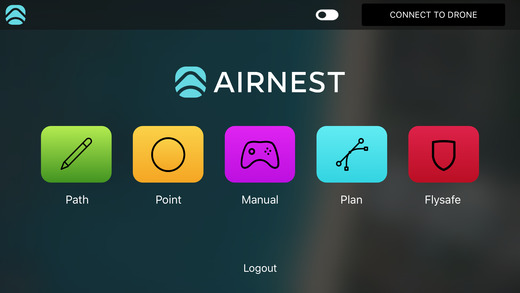
PLAN
• Design stunning aerial videos just by drawing a flight path on a map or tapping specific waypoints**
• Set up to FIVE points of interest throughout your flight
• Set altitude for your points of interest
• Save your flights!
• Adjust corner curves by simply dragging them
• Easily switch to a live stream of your drone's camera during flight
• Set beginning and ending altitudes to get that perfect boom or arched shot
PATH
• Design stunning aerial videos just by drawing a flight path on a map**
• Tap where you want the camera to point throughout the flight
• Save up to 25 flight plans with just one tap
• Easily switch to a live stream of your drone's camera during flight
• Set beginning and ending altitudes to get that perfect boom or arched shot
POINT
• Capture aerial shots quickly and easily with one touch
• Tap where you want your drone to go on a map
• Motion Camera allows you to control your drone's camera just by panning and tilting your iOS device.
CAPTURE
• Provides a live feed of your drone's camera while you fly using your remote controller for FPV first person view.
• Take off and land with one button press
• Swipe to switch between photo and video modes
FLYSAFE
• Know where it's safe to fly even before you take off
• Visualizes the no-fly zones around airports
• Provides live, local weather information based on your location
*Compatible with the DJI Phantom 4, Phantom 3 Standard, 4K, Professional, Advanced, DJI Inspire 1, and DJI Inspire 1 Pro.
**Be sure to upgrade to the latest DJI firmware before using Airnest
Airnest's cloud-based logging and analytics platform automatically syncs your flight logs from the app. Your airnest.com account provides realtime playback and metrics tracking - including battery performance, GPS health, orientation, altitude, and more.
PLAN
• Design stunning aerial videos just by drawing a flight path on a map or tapping specific waypoints**
• Set up to FIVE points of interest throughout your flight
• Set altitude for your points of interest
• Save your flights!
• Adjust corner curves by simply dragging them
• Easily switch to a live stream of your drone's camera during flight
• Set beginning and ending altitudes to get that perfect boom or arched shot
PATH
• Design stunning aerial videos just by drawing a flight path on a map**
• Tap where you want the camera to point throughout the flight
• Save up to 25 flight plans with just one tap
• Easily switch to a live stream of your drone's camera during flight
• Set beginning and ending altitudes to get that perfect boom or arched shot
POINT
• Capture aerial shots quickly and easily with one touch
• Tap where you want your drone to go on a map
• Motion Camera allows you to control your drone's camera just by panning and tilting your iOS device.
CAPTURE
• Provides a live feed of your drone's camera while you fly using your remote controller for FPV first person view.
• Take off and land with one button press
• Swipe to switch between photo and video modes
FLYSAFE
• Know where it's safe to fly even before you take off
• Visualizes the no-fly zones around airports
• Provides live, local weather information based on your location
*Compatible with the DJI Phantom 4, Phantom 3 Standard, 4K, Professional, Advanced, DJI Inspire 1, and DJI Inspire 1 Pro.
**Be sure to upgrade to the latest DJI firmware before using Airnest
What's New in Airnest 2.1 >
Google Maps integration
Now supports Airnest's cloud-based flight logging and analytics platform.