PeakVisor (ru.routes.peakvisor): Peak Finder with 3D Maps, Now off to the mountains!, Now off to the mountains!...Read More > or Download Now >
PeakVisor for iPhone and iPad
Tech Specs
- • Latest Version: 5.5
- • Updated: April 20, 2024
- • Requires: iOS 13.0 and up
- • Developer: Routes Software SRL
- • Age Rating: 4+
User Reviews

- • Rating Average
- 4.5 out of 5
- • Rating Users
- 10441
Download Count
- • Total Downloads
- 64
- • Current Version Downloads
- 0
You can download the the latest version of PeakVisor or explore its version history.
Also PeakVisor is included in the following collections:
More About PeakVisor
"PeakVisor is a seemingly magical app that instantly recognizes the name of any mountain peak that comes into view using a combination of your phone’s camera" - Atlas & Boots
"PeakVisor uses your iPhone's camera and augmented reality (AR) technology to display names and elevation of nearby peaks. The information will appear on your phone like magic." - App Store, Take the Trail Less Traveled
"A lovely little app that uses your phone’s camera and the power of augmented reality to identify any mountain you aim the camera at." - Digital Trends
Key Features:
● Mountains Identification
Identify more than a million hills & mountains all over the world and get a detailed profile for each one of them, including altitude, topographic prominence, mountain range, what national parks or reserves it may belong to, as well as photos and Wikipedia articles. It is one of the most useful Augmented Reality technology applications on the market today.
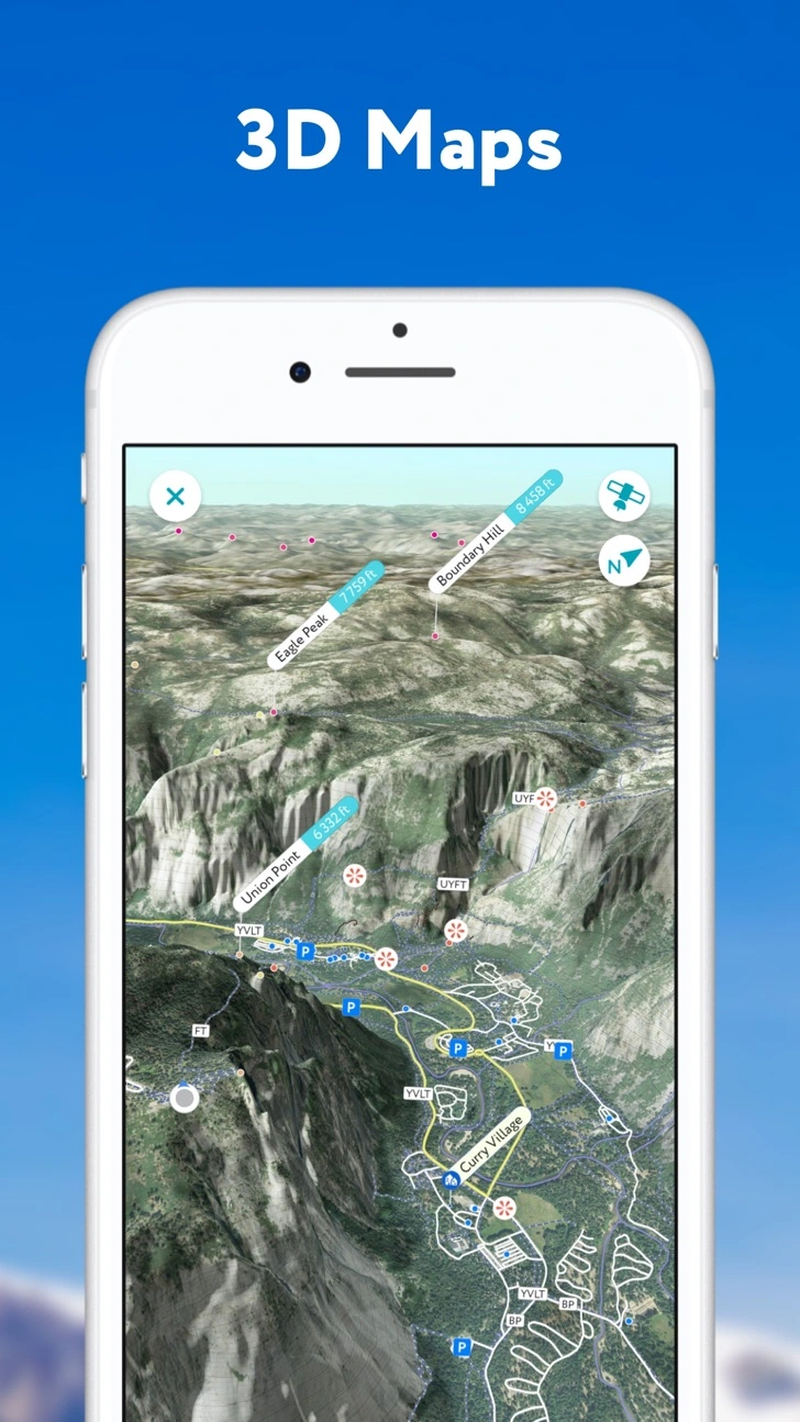
● 3D Maps
Get your topo maps of the future. Cutting edge technology with high-precision terrain modeling allows simple, yet effective insight into the landscape of the mountains. It is the most convenient way to explore a mountainous area, its trails, summits, passes, viewpoints, and even parking areas.
● Hiking Route Planner
A vast network of worldwide hiking trails and walking pathways included in PeakVisor’s 3D Maps will help you compose a hiking route, which includes, evaluating the distance you can expect to hike, as well as a route’s elevation profile, and estimated time for completion. To help you plan your route we’ve included points of interest in our 3D Maps such as mountain huts, parking lots, cable cars, viewpoints, castles, etc.
● Everything works Offline
Internet connection is not a prerequisite for the PeakVisor app if you’ve purchased our PRO option. All the data is downloadable and ready for use no matter where you are or what altitude you might be at.
● Identifying Mountains in Photos
If you have photos from previous hikes that you did not take through the app, you can still find out what peaks you saw by download your images into the PeakVisor app and adding a digital overlay of the mountains with names and altitudes of all the peaks in view.
● Photo Planning
PeakVisor’s Sun and Moon trajectories come super handy when planning the perfect time to take pictures.
PeakVisor is the Swiss army knife of outdoor adventure and will soon be indispensable to you future hiking needs. Just keep it in your backpack and you'll get value from it every time you’re on the trail!
PeakVisor PRO is a premium subscription which allows you to use the app without an Internet connection. Unlock exceptional offline capabilities and support PeakVisor development. By subscribing to PeakVisor PRO you make it possible for us to focus on ever-improving the app and bring a better version every week, regularly update your maps globally so you will always be up to date. PeakVisor PRO is available as a monthly or an annual subscription.
If you choose to get PeakVisor PRO then the payment will be charged to your Apple ID account once you confirm your purchase. The subscription automatically renews unless it is canceled at least 24 hours before the end of the current period. Your account will be charged for renewal within 24 hours before the end of the current period. You can manage and cancel your subscriptions through the App Store account settings after purchase. Any unused portion of a free trial period, if offered, will be forfeited when the user purchases a subscription to the publication, where applicable. You may find more details in our Terms and Privacy Policy available by the link => https://peakvisor.com/en/terms.html
If you have any questions or just feel like talking about mountains, please contact us at peakvisor@routes.tips
What's New in PeakVisor 5.5 >
Introducing our new weather forecast feature, now available for any hiking location of your choice. We've also added snow depth details to the 3D map. Plus, don't forget to check the app to find out which mountain huts are currently open!
PeakVisor has included mountain huts on its 3D Maps for years. This week, we expanded this feature to include whether or not the hut is open and closed, as well as schedules for dining and overnight stays. Our dataset now includes thousands of huts, with more added weekly. The latest version brings us one step closer to PeakVisor’s goal of being a one-stop shop to plan an adventure.
Even more UX improvements and bug fixes.