AOPA FlyQ EFB 1.4.1 for iPad
A Free Navigation App
Published By Aircraft Owners and Pilots Association
AOPA FlyQ EFB: Put simply, FlyQ EFB from Seattle Avionics makes your flying easier and safer by thoughtfully integrating powerful features such as split screen,...Read More > or Download Now >
AOPA FlyQ EFB for iPad
Tech Specs
- • Latest Version: 1.4.1
- • Updated: November 6, 2014
- • Requires: iOS 6.0 and up
- • Developer: Aircraft Owners and Pilots Association
- • Age Rating: 4+
User Reviews

- • Rating Average
- 4 out of 5
- • Rating Users
- 340
Download Count
- • Total Downloads
- 6
- • Current Version Downloads
- 3
You can download the the latest version of AOPA FlyQ EFB or explore its version history.
More About AOPA FlyQ EFB
Put simply, FlyQ EFB from Seattle Avionics makes your flying easier and safer by thoughtfully integrating powerful features such as split screen, terrain and obstacle avoidance, 3D synthetic vision, ADS-B weather and traffic from many devices, plates on the map, extended runways, distance measurement systems, and wind-optimized flight planning.
> Maps Your Way
+ 2D maps or 3D Synthetic Vision
+ Sectionals or IFR charts
+ Radar
+ Satellite
+ Fuel prices for more than 2,000 airports
+ Obstacle and terrain avoidance
+ AIRMETs/SIGMETs
+ METARs/TAFs
+ ADS-B weather and traffic from many receivers
+ Extended runways with right-pattern indicators
+ Procedures on the map
+ Rings and Extended Courseline
+ Search and Rescue grid
You can mix and match all of these layers on the 2D map.
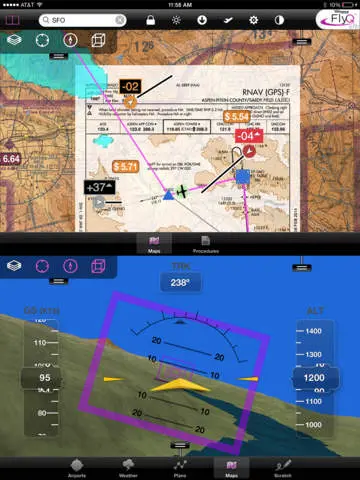
One tap switches from 2D to 3D Synthetic Vision or back again. Syn Vis includes HITS boxes and a fighter-style EFIS display. 3D terrain comes alive with true seamless Sectionals or IFR Enroute charts wrapped around the terrain. Terrain and obstacle avoidance also work in 3D.
Add an AHRS for even more accuracy.
Fly at night? FlyQ EFB includes a Night Mode that preserves your night vision.
Split screen or single screen? FlyQ begins in full-screen mode using simple tabs to select major function: Airports, Weather, Plans, Maps, Procedures, and Multi-page Scratchpad. Tap the Split button and FlyQ shows a map plus any other type of info such as a second map or a geo-referenced approach procedure.
> Procedures
FlyQ includes Seattle Avionics geo-referenced approach plates and airport diagrams. Split screen mode can show a map and a procedure simultaneously. Swipe to switch procedures. Even overlay procedures on a map.
> Flight Planning
FlyQ plans flights any way you like:
1. Enter a series of indents in the Search box.
2. Use the Plans tab to automatically compute a wind-optimized course along Victor, Jet airways, or GPS Direct. In about 30 seconds, you'll see a complete flight plan with all the navaids and fixes -- not just a straight line. FlyQ uses expected winds to plot the fastest course, saving time and money on every flight.
3. Rubber-band flight plans directly on the map.
Flight plans are automatically shared between all your devices so plans created on your iPhone are automatically available on your iPad and vice versa.
> Weather
FlyQ EFB uses your GPS position to display the current temperature, Nexrad images, local METARs and TAFs, and a plain-text seven-day forecast. It also includes patent-pending Graphical Wind Optimizer that uses simple red and green bars to show the headwind or tailwind you'll get at different altitudes. There is also a gallery of US and Canadian weather images.
Even connect your Clarity, Dual, SkyRadar, or iLevil ADS-B receiver and get weather and traffic delivered as you fly!
> Airport Information
FlyQ makes it easy get airport information: Enter an ident or name in the top Search box, double-tap a map, touch any entry in your flight plan, or watch a list of nearby airports that updates as you fly. You'll be amazed how clear the presentation is. No simple "data dump", the Airport screen was carefully crafted to show key operational info, runways, frequencies, and even satellite images and runway diagrams, on a single screen. Weather, approach procedures, A/FD, and the AOPA Airports directory are just a tap away.
> Data Manager
FlyQ makes it painless to download new data every month: spin and zoom a 3D globe to visually select the states you're interested in and FlyQ does the rest. FlyQ downloads incredibly fast because it downloads just the new information each month, not all data. This can save you hours (the first download takes longer because FlyQ downloads terrain data).
> Try it before you buy it
Experience everything FlyQ EFB offers with a free 30-day subscription.
> Maps Your Way
+ 2D maps or 3D Synthetic Vision
+ Sectionals or IFR charts
+ Radar
+ Satellite
+ Fuel prices for more than 2,000 airports
+ Obstacle and terrain avoidance
+ AIRMETs/SIGMETs
+ METARs/TAFs
+ ADS-B weather and traffic from many receivers
+ Extended runways with right-pattern indicators
+ Procedures on the map
+ Rings and Extended Courseline
+ Search and Rescue grid
You can mix and match all of these layers on the 2D map.
One tap switches from 2D to 3D Synthetic Vision or back again. Syn Vis includes HITS boxes and a fighter-style EFIS display. 3D terrain comes alive with true seamless Sectionals or IFR Enroute charts wrapped around the terrain. Terrain and obstacle avoidance also work in 3D.
Add an AHRS for even more accuracy.
Fly at night? FlyQ EFB includes a Night Mode that preserves your night vision.
Split screen or single screen? FlyQ begins in full-screen mode using simple tabs to select major function: Airports, Weather, Plans, Maps, Procedures, and Multi-page Scratchpad. Tap the Split button and FlyQ shows a map plus any other type of info such as a second map or a geo-referenced approach procedure.
> Procedures
FlyQ includes Seattle Avionics geo-referenced approach plates and airport diagrams. Split screen mode can show a map and a procedure simultaneously. Swipe to switch procedures. Even overlay procedures on a map.
> Flight Planning
FlyQ plans flights any way you like:
1. Enter a series of indents in the Search box.
2. Use the Plans tab to automatically compute a wind-optimized course along Victor, Jet airways, or GPS Direct. In about 30 seconds, you'll see a complete flight plan with all the navaids and fixes -- not just a straight line. FlyQ uses expected winds to plot the fastest course, saving time and money on every flight.
3. Rubber-band flight plans directly on the map.
Flight plans are automatically shared between all your devices so plans created on your iPhone are automatically available on your iPad and vice versa.
> Weather
FlyQ EFB uses your GPS position to display the current temperature, Nexrad images, local METARs and TAFs, and a plain-text seven-day forecast. It also includes patent-pending Graphical Wind Optimizer that uses simple red and green bars to show the headwind or tailwind you'll get at different altitudes. There is also a gallery of US and Canadian weather images.
Even connect your Clarity, Dual, SkyRadar, or iLevil ADS-B receiver and get weather and traffic delivered as you fly!
> Airport Information
FlyQ makes it easy get airport information: Enter an ident or name in the top Search box, double-tap a map, touch any entry in your flight plan, or watch a list of nearby airports that updates as you fly. You'll be amazed how clear the presentation is. No simple "data dump", the Airport screen was carefully crafted to show key operational info, runways, frequencies, and even satellite images and runway diagrams, on a single screen. Weather, approach procedures, A/FD, and the AOPA Airports directory are just a tap away.
> Data Manager
FlyQ makes it painless to download new data every month: spin and zoom a 3D globe to visually select the states you're interested in and FlyQ does the rest. FlyQ downloads incredibly fast because it downloads just the new information each month, not all data. This can save you hours (the first download takes longer because FlyQ downloads terrain data).
> Try it before you buy it
Experience everything FlyQ EFB offers with a free 30-day subscription.
What's New in AOPA FlyQ EFB 1.4.1 >
Bug Fixes